Tag: WPA
-
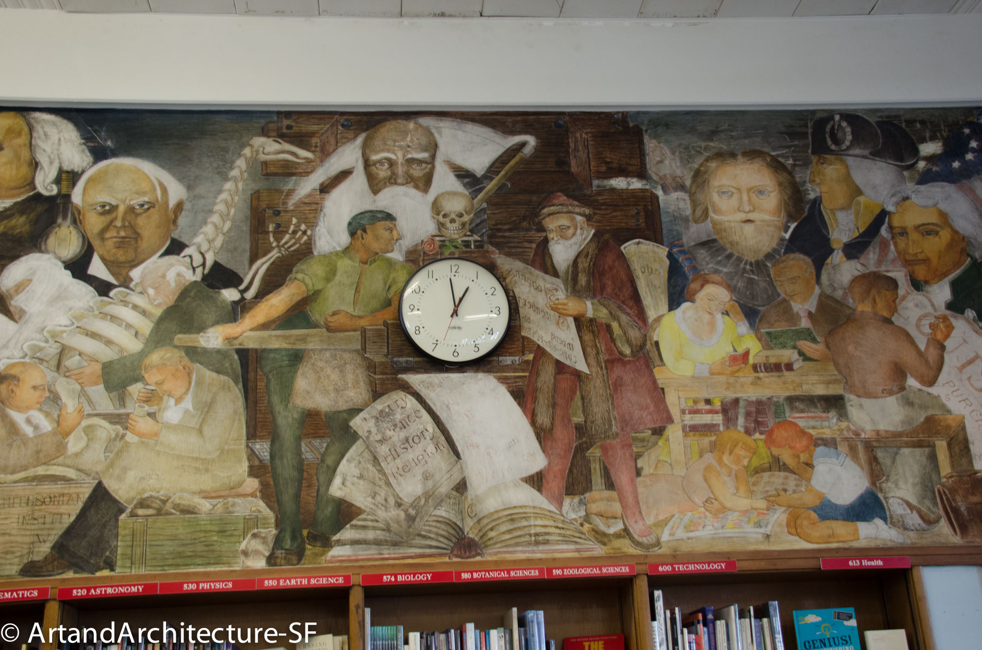
“Advancement of Learning through the Printing Press” by Lucien Labaudt
George Washington High School 600 32nd Avenue This mural, by Lucien Labaudt resides on the east wall of the library at George Washington High School it was completed in 1936 as part of the WPA. In this mural you will find such notables as Abraham Lincoln, George Washington, Junipero Serra, Benjamin Franklin, Thomas Alva Edison,…
-
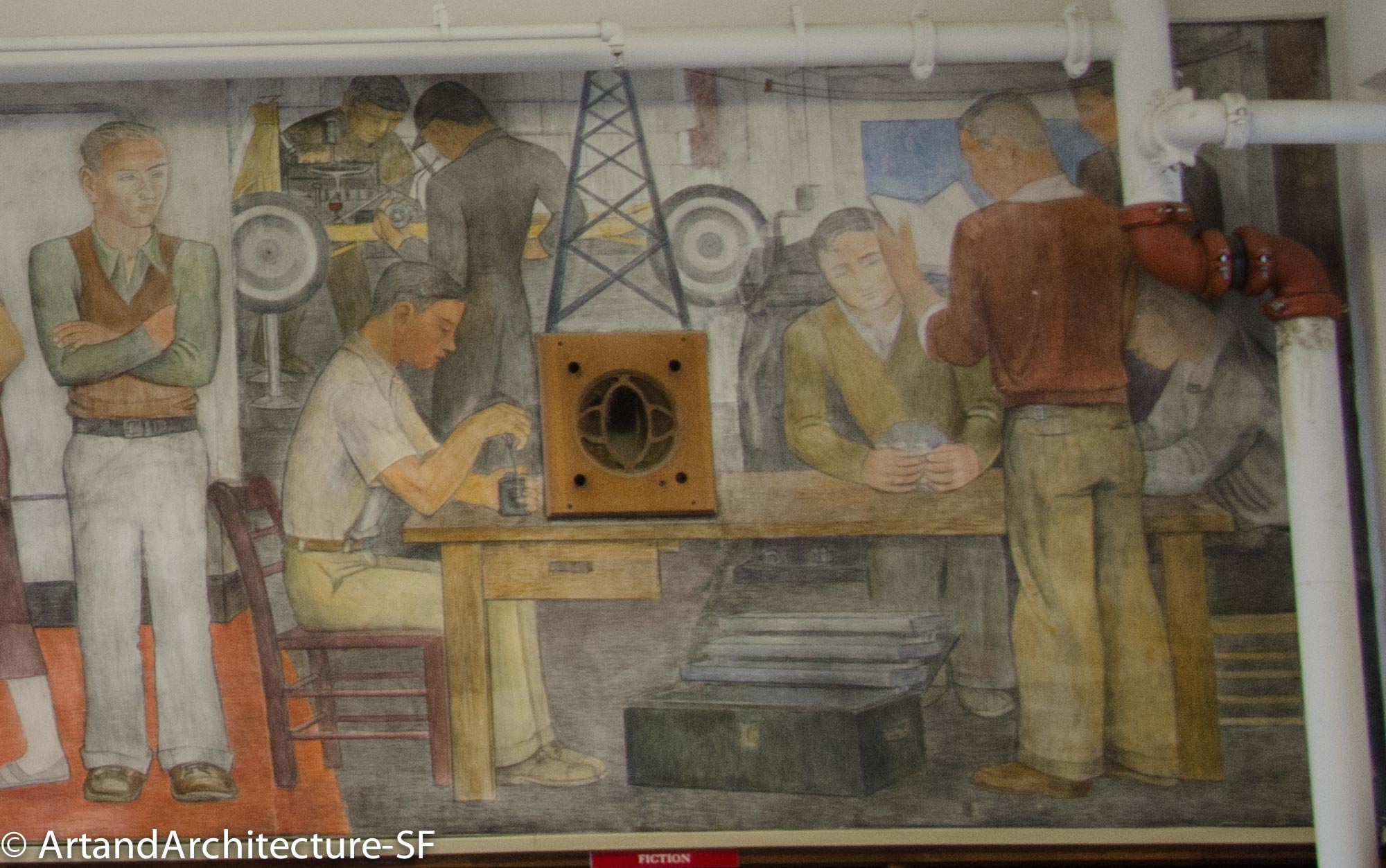
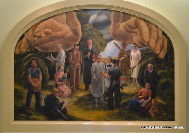
“Contemporary Education” by Ralph Stockpole
George Washington High Schoool 600 32nd Street Library Contemporary Education by Ralph Stackpole resides on the west wall of the library at George Washington High School. It was painted in 1936 as part of the WPA and the New Deal. Newspaper accounts at the time state that Stackpole was “interpreting contemporary education in the American…
-
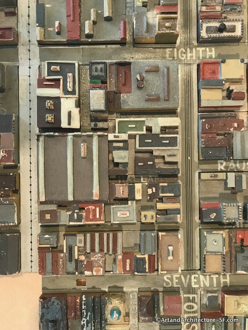
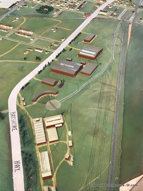
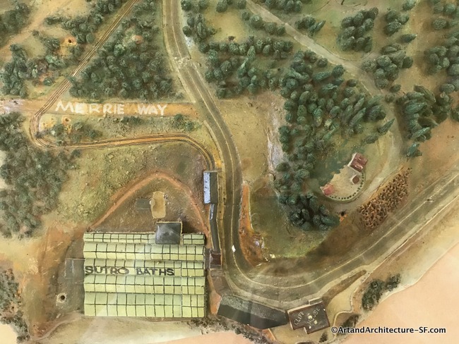
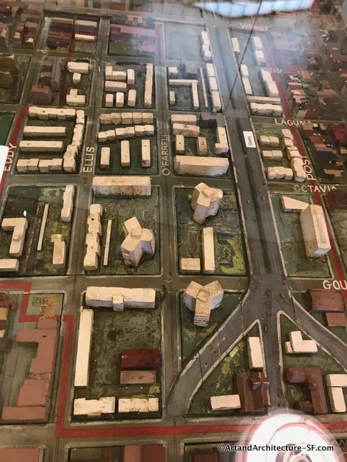
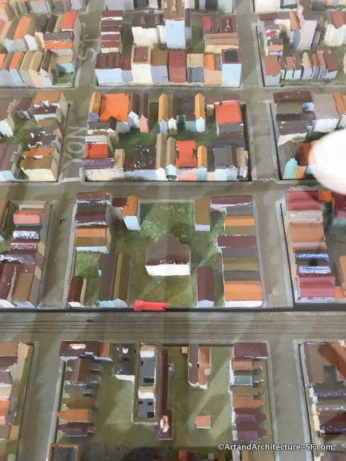
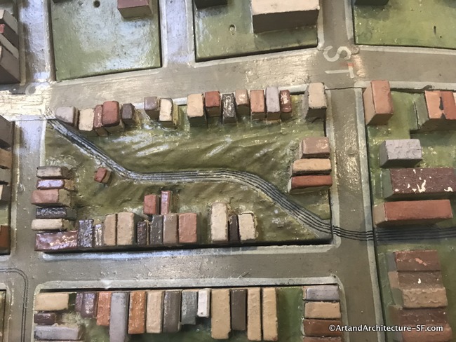
WPA Map of San Francisco
January to May 2019 At San Francisco’s Public Libraries This exhibit is something after my own heart. A WPA map of San Francisco combines my love of the projects that stemmed from the WPA and the history of San Francisco. This exhibit is called Take Part and more information about the locations of the parts…
-
WPA Map of San Francisco Part 10 – Visitation Valley and Bayview Branch Libraries
Visitation Valley Branch Library Bayview Branch Library This is installment ten about the pieces of the WPA map that are being displayed as part of the joint program, Take Part, between SFMOMA and the San Francisco Library. You can read the first nine installments here. I apologize for the poor quality of the photographs.…
-
WPA Map of San Francisco -Bernal, Excelsior, Ingleside and Portola Branch Libraries
Bernal Branch Library Excelsior Branch Library Ingleside Branch Library Portola Branch Library This is installment nine of the pieces of the WPA map that are being displayed as part of the joint program, Take Part, between SFMOMA and the San Francisco Library. You can read the first eight installments here. I apologize for the poor quality…
-
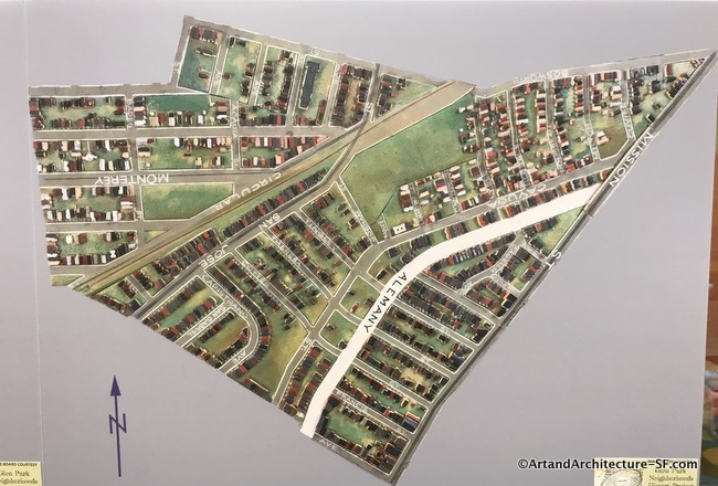
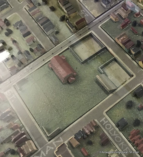
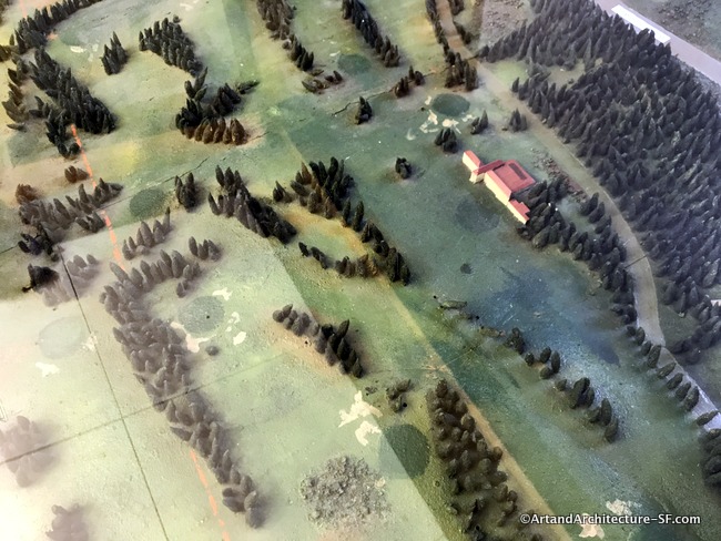
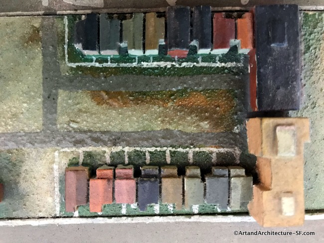
WPA map of San Francisco Part 8 -Ocean View and Glen Park Branch Libraries
Ocean View Branch Library Glen Park Branch Library This is installment eight about the pieces of the WPA map that are being displayed as part of the joint program, Take Part, between SFMOMA and the San Francisco Library. You can read the first seven installments here. I apologize for the poor quality of the photographs. Most…
-
WPA Map of San Francisco Part 7 – West Portal and Merced Branch Libraries
West Portal Branch Library Merced Branch Library This is installment seven about the pieces of the WPA map that are being displayed as part of the joint program, Take Part, between SFMOMA and the San Francisco Library. You can read the first six installments here. I apologize for the poor quality of the photographs. Most every…
-
WPA Map of San Francisco Part 6 – Sunset, Ortega and Parkside
Sunset Branch Library Ortega Branch Library Parkside Branch Library This is installment six of the pieces of the WPA map that are being displayed as part of the joint program, Take Part, between SFMOMA and the San Francisco Library. You can read the first Five installments here. I apologize for the poor quality of the photographs.…
-
WPA Map of San Francisco Part 5 – Richmond and Park Branch Libraries
Richmond Branch Library Park Branch Library This is installment five of the pieces of the WPA map that are being displayed as part of the joint program, Take Part, between SFMOMA and the San Francisco Library. You can read the first four installments here. I apologize for the poor quality of the photographs. Most every…
-
WPA Map of San Francisco Part 4 – Western Addition and Anza Branch Libraries
Western Addition Branch Library Anza Branch Library This is installment four of the pieces of the WPA map that are being displayed as part of the joint program, Take Part, between SFMOMA and the San Francisco Library. You can read the first three installments here. I apologize for the poor quality of the photographs. Most every…
-
WPA Map of San Francisco Part 3 – Golden Gate Valley, Marina and Presidio Branch Libraries
Golden Gate Valley Branch Library Marina Branch Library Presidio Branch Library This is installment three of the pieces of the WPA map that are being displayed as part of the joint program, Take Part, between SFMOMA and the San Francisco Library. You can read the first two installments here. I apologize for the poor quality of…
-
WPA Map of San Francisco – Part 2 – SFMOMA, Mission, Noe Valley and Eureka Valley Branch Libraries
SFMOMA Mission Branch Library Noe Valley Library Eureka Valley Library This is the second post in a series covering the joint SF Library system and SFMOMA project Take Part showing the map of San Francisco built by the WPA. Click here for Part 1 SFMOMA The hub of the San Francisco commuter bus and Greyhound…
-
WPA Murals at Laguna Honda Hospital
Laguna Honda Hospital 375 Laguna Honda Boulevard Foresthill Professions by Glen Wessels is one of five murals in the entry to the older wing of Laguna Honda Hospital. These five 8′ x 6′ murals were painted in 1934 with funding from the PWAP (Public Works Art Projects). Glenn Anthony Wessels was born in Cape Town, South…
-
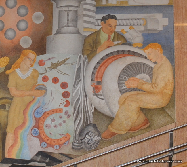
Frederick Olmsted at CCSF
CCSF Phelan Campus Hall of Science The Theory of Science is the title of two murals at the west entrance stairs of the Science Hall. The murals show students engaged in various branches of scientific research such as viewing bacteria through a microscope, conducting field research, and excavating dinosaur remains. These were painted in 1941…
-

Building the Iron Horse
Laguna Honda Hospital Lobby of the Pavillion 375 Laguna Honda Boulevard Forest Hill Owen Smith’s WPA-style mosaic murals depicting the building of the Golden Gate Bridge pay homage to Glen Wessel’s Professions mural series in the historic Laguna Honda lobby and provide a visual continuity between the old and the new buildings. The artist chose…
-

John Park WPA Murals
John Muir Elementary 380 Webster Hayes Valley As you enter John Muir Elementary school you are greeted with three lunettes. In the lunettes are WPA murals by artist David Park. These murals were done in 1934, the same year that park joined the WPA. These three are painted in the Socialist Realism style. The three…
-

John Muir Elementary School
John Muir Elementary School 380 Webster Hayes Valley In the ten years between 1920 and 1930 San Francisco erected 49 new school buildings, with a 50th approved in 1931. This was all accomplished just 80 years after the birth of the San Francisco School System. These 50 school buildings represented an investment, at that time,…
-

Hearst Grizzly Gulch
San Francisco Zoo This grizzly by Tom Schrey graces the Hearst Grizzly Gulch building at the SF Zoo. Tom has a degree from California College of the Arts and presently works at Artworks Foundry. The following was excerpted from a June 15, 2007 SF Gate article by Patricia Yollin: Three summers ago, two…
-

Bruton Sisters WPA Mural at the San Francisco Zoo
San Francisco Zoo Mother’s Building These murals, on the Mother’s Building at the San Francisco Zoo were WPA projects. They were done by three sisters: Esther Bruton, Helen Bruton and Margaret Bruton. Helen Bruton has murals in downtown San Francisco that you can read about here. Here is an excerpt explaining the sisters work on the…
-

Sargent Johnson Tile’s the Maritime Museum
Maritime Museum Aquatic Park This 14′ x 125′ glazed tile mural was created by Sargent Johnson in 1939 with the help of FAP (Federal Art Project) funds. The east end, however, is incomplete. When the project began, the building was to be a publicly-accessible bathhouse. However, shortly after it opened, the City leased a majority…
-

Sargent Johnson and Aquatic Park
Maritime Museum Aquatic Park This carved sandstone entry to the Maritime Museum was done as a Federal Arts Project (FAP) by Sargent Johnson. Johnson was in this site before for the log. This building was originally a New Deal WPA (Works Progress Administration) building called the Aquatic Park Bathhouse. Construction began in 1936 and the…
-

Log
Corner of Webster and Golden Gate Avenue Park behind the Rosa Parks Senior Center Western Addition I have driven past this park one thousand times and have always wondered about this tree stump. Then one day my dear friend Netra Roston told me about an artist named Sargent Johnson. Sargent Johnson was not a stranger…
-
Fire Station #8 a WPA gem on Bluxome Street
36 Bluxome Street SOMA South of the Slot Fire Station Number 8 was built in 1939 as a result of the WPA The San Francisco Fire Department was a big beneficiary of W.P.A. The Department’s 1974 Historical Review noted, “One of the few advances made by the Department in these lean years resulted from the…
-
Washington High School and the WPA
George Washington High School 600 32nd Avenue Richmond District George Washington High School opened on August 4, 1936, to serve as a secondary school for the people of San Francisco’s Richmond District. The school was built on a budget of $8,000,000 on a site overlooking the Golden Gate Bridge. The architect was Timothy Pflueger, here he begins…
-
Jaques Schnier on Treasure Island
Treasure Island Building #1 These two cast stone sculpture represents India and were done by Jacques Schnier for the Golden Gate International Exposition. They have been known by several names, including “The Tree of Life,” but the preferred name is “Spirit of India.” These are just two of twenty that were part of the Unity…
-
Adaline Kent sculptures on Treasure Island
Treasure Island Building #1 These cast stone statues are part of Adaline Kent’s group of three Pacific Islander statues that were among the twenty Pacific Unity sculptures produced for the Court of the Pacifica at the 1939-1940 Golden Gate International Exposition. The two shown here are listening to a stringed instrument (most likely a ukelele)…
-
Helen Phillips and the Golden Gate Exposition
Treasure Island Building #1 This cast stone sculpture is by Helen Phillips. Titled Flutist, it is from the Chinese Musicians Group produced for the Golden Gate International Exposition. This was one of a group of 20 sculptures titled Unity that were produced for the Court of the Pacific. This is from Helen Phillips obituary: Phillips…
-
Florence Nightingale
Laguna Honda Hospital Forest Hill / Twin Peaks This graceful painted cast stone statue of Florence Nightingale titled Lady of the Lamp is by David Edstrom and was done in 1937. The project was part of the WPA (Works Progress Administration) Federal Artists Program. The statue sat in the Court of the Seven Seas during the…
-
Horseshoe Courts of Golden Gate Park
Horseshoe Pits Golden Gate Park There are sixteen courts in a very out of the way spot of the park, not far from McClaren Lodge. The site was developed out of a rock quarry during 1934 as a WPA project. There are two concrete bas-reliefs created on the face of the rocks. The artist was…
-
Sarah B. Cooper Brings the West its First Kindergarten
Golden Gate Park Near the Sharon Art Center This memorial to Sarah B. Cooper was placed in the park by the Golden Gate Kindergarten Association in 1923. This area sits on the other side of the carousel from the Koret Childrens Playground. Sarah Cooper was instrumental in the Kindergarten Movement of San Francisco. Here, from…