Lover’s Lane

 Posted by on December 22, 2014
Dec 222014
 

Lover’s Lane
The Presidio

Lover's Lane Presidio San Francisco

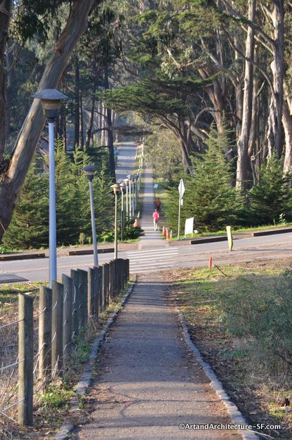
There is a small trail in the Presidio titled Lover’s Lane. It has a well known history that you can read on the plaque found at one end of what is still existing of this trail.

Shanks mare and Lovers Lane

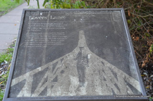
The sign reads: “This trail has witnessed the passing of Spanish soldiers, Franciscan missionaries and American soldiers of two centuries  It is perhaps the oldest travel corridor in San Francisco.  In 1776 this path connected the Spanish Presidio with the mission, three miles to the southeast.  During the 1860s it became the main route used by off-duty solders to walk into San Francisco.  Many of those men made the trip into town to meet their sweethearts, and the trail became known as Lovers’ Lane.”

Keep in mind that when they say walk into San Francisco, San Francisco at that time was the mission.  However, what you also must keep in mind is that those three miles were sand dunes. That is right, not nice dirt trails, or gravel roads but hard to trod, rolling hills of sand.

Sand Dune Map San Francisco 1800's

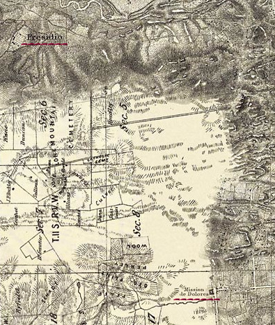
 This map is a compilation of several maps from the 1860’s, remember lovers lane began in 1776. I have underlined in red the Presidio at the top and the Mission on the bottom right. The original, and enlargeable map can be found here.  It is part of the San Francisco Watershed Finder series of maps.  This series of maps was put together with the help of Joel Pomerantz of ThinkWalks, Joel gives walks all over town to discuss these watersheds and the hidden streams and creeks of San Francisco.

If you aren’t really great at reading topo maps here are some photos from San Francisco, while from the late 1800s and early 1900s sand dunes were still prevalent.
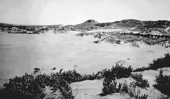
Late 19th Century The Richmond District looking towards Lone Mountain Photograph from a Private Collection

Late 19th Century
The Richmond District looking towards Lone Mountain
Photograph from a Private Collection

Sunset District 1900 Photo courtesy of Greg Gaar

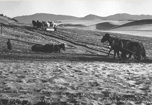
Golden Gate Park construction with the Sunset District in the back – 1900 
Photo courtesy of Greg Gaar

So imagine how hard it must have been to trod for 3 miles over these sand dunes. Also, in 1776, these would have been the Spanish soldiers that came with Juan Bautista de Anza, and I am rather sure their boots weren’t the easiest to cross these sand dunes in either.  The need to get back to town had to have been rather  pressing to make a trek like that.

oldest bridge in San Francisco

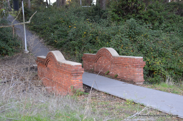
This bridge, which marks either the end or beginning of your trip, depending on where you start, was built around 1885.  The bridge crosses Tennessee Hollow and a creek, whose source is El Polin Spring.

The presence of the spring was a reason that the Presidio was a viable place for a garrison. While not enough water for cattle and crops, which is why the Mission is 3 miles away, it was enough for horses and men.  During the Spanish American War of 1898, the First Tennessee Volunteer Infantry Regiment camped here, providing the name Tennessee Hollow.

While walking the Lover’s Lane path keep an eye out for Andy Goldsworthy’s Wood Line. 

Utility Boxes get Dressed Up

 Posted by on January 18, 2013
Jan 182013
 

Duboce and Church
Castro

Mona Caron at Duboce and Church Utility Boxes

Mona Caron, who created the adjacent Bicycle Coalition mural on the back of the Safeway has added new touches to the Muni utility boxes on the sidewalk. On one side of the boxes, bicyclists entering the Wiggle are greeted by an illustrated flowing banner that lists the names of the streets that make up the route. On the other side, pedestrians are treated with a window to a re-imagined intersection featuring an uncovered Sans Souci Creek (which once roughly followed the path of the Wiggle).

The Wiggle on Utility Boxes

The title of this box is Manifestation Station.


Mona Caron Bicycle Coalition Mural Utility Box

This photo, from Mona Caron’s website, shows exactly how the box was meant to be viewed.

Update: There was fire in this particular utility box, and the utility company has replaced it with a plain unpainted box, Mona’s beautiful creation is not to return.  But you can enjoy her video about it here:

Cross the street, and you get lovely depictions of “weeds” sprouting from the ground.  “They may be tiny yet they push through concrete. They are everywhere and yet unseen. But the more they get stepped on, the stronger they grow back.”…Mona Caron

Mona Caron

Mona Caron has several murals throughout San Francisco.

Mona Caron

These boxes are part of the Church and Duboce Track Improvement Project by the SFMTA

For a great day spent learning about the area and the mural check out ThinkWalks, if you don’t have time to actually take a walk, they have a wonderful full color description of the mural with facts, trivia, and lots of bits of San Francisco History in their store.

S.F. Bicycle Coalition Mural

 Posted by on January 11, 2012
Jan 112012
 
Castro/Duboce Avenue/Nob Hill
Back of
2020 Market Street


In 1972 BART built the Market Street subway, including Muni Metro. Along the Duboce Avenue tunnel entrance was a single eastbound lane for cars. During the 1994 closure of the street, for construction, The Bicycle Coalition worked to show that this street, which when used by both cyclists and cars was highly dangerous, was better served as a bikeway.  They were successful.

In 1995 Peter Tannen of the SF Bicycle Coalition obtained grant funds and Joel Pomerantz, then, co-founder of the bicycle coalition but now, leader of ThinkWalks, was recruited to produce a mural celebrating the first street closed to cars specifically for bicycles.
Joel convinced Mona Caron that she was capable of doing a mural and this was the result.  Mona has been in this site many times before, however, this was her first mural.  The mural is on the back side of the Market Street Safeway along the Duboce Bike Trail where muni heads underground.

According to Mona Caron’s website “At the center of the block long, 6,075 square foot mural is a depiction of the bikeway itself, (complete with its mural,) in geographic and historical context along the ancient streambed which cyclists follow to avoid hills. (The zig-zagging route is now known as “the Wiggle.”) To the east of the Wiggle is Downtown, to the West, residential neighborhoods, Golden Gate Park and, finally, the beach.

At the east end of the wall (downtown), Market Street’s bicycles are seen transforming into pedal-powered flying machines which rise out of the morass of pollution and gridlock. The scene alludes to the subversive nature of Critical Mass in particular, and generally symbolizes the freedom experienced by those with visions of alternatives to the status quo, represented in the mural by frowning corporate skyscrapers. Each of the flying contraptions trails its pilot’s dream of utopia in the form of a golden banner. The whole rest of the mural, westwards from this scene, starts in the shape of one of these golden banners, suggesting that this mural depicts just one of many ideas that make up our collective vision. Ours happens to deal with the issue of transportation, and the City depicted in the rest of the mural is a traffic and pollution free one, where the community takes back the space which now fragments it: the street.”

There is a fabulous, color photo, panel by panel, description of this mural, with stories, trivia and great bits and pieces of San Francisco history available at the Thinkwalks store.

*

*

***

*

Check out this post about the utility boxes across the street.

The 1852 Shoreline

 Posted by on January 27, 2000
Jan 272000
 

162 King Street
South Beach

South Beach Shoreline

Here is a map of San Francisco prior to 1852.

Pre 1852 Map of San Francisco

In this map Townsend is the western-most street on the waterfront, one block northwest of King Street.

Southbeach Shoreline 1852 in sidewalk on king street

Thanks to Found SF and the Oakland Museum, you can see what the area looks like today:

Mission Bay old and New

brass squiggly line in sidewalk

If you are interested in more information about the  water that lies under our fair city, I suggest you take one of Joel Pomerantz’s Thinkwalks.  He is a local expert on the indigenous water of San Francisco, and gives fascinating tours around different parts of the city.

The waterfront art project is part of the San Francisco Art Commission for the Waterfront Transportation Projects.

error: Content is protected !!